Climate Change Made North-West Iberia's August 2025 Burned Area About Three Times Larger, State of Wildfires Report Says
The State of Wildfires 2025 to 2026 report, published in Earth System Science Data, says climate change made the August 2025 burned area in central and northern Portugal and north-west Spain about 2.93 times larger.
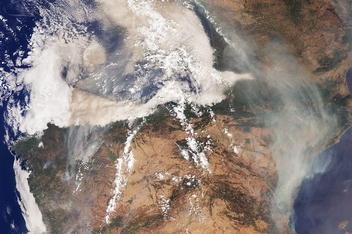
Human-driven climate change made the area burned in north-west Iberia in August 2025 about 2.93 times larger than it would have been in a pre-industrial climate, according to State of Wildfires 2025 to 2026, published on 11 November in the journal Earth System Science Data. The study region covers central and northern Portugal and north-west Spain, where most of the burning came between 8 and 26 August.
The authors include scientists at the UK Met Office, the European Centre for Medium-Range Weather Forecasts (ECMWF), the University of East Anglia and the UK Centre for Ecology and Hydrology. Público reported the Portuguese findings on Saturday.
What the scientists found
The authors say climate change very likely (94 percent) increased the area burned, though the 2.93 figure's modelled range runs from 0.73 to more than 100. Fire weather like August 2025 was about three times more likely (best estimate 3.63, modelled range 0.14 to 657), and analysis of observed weather found such conditions would have been "virtually impossible" in the pre-industrial climate. A burned area of this size is now around four times more likely.
For Portugal, the paper cites the European Forest Fire Information System (EFFIS) estimate of about 2,789 km2 burned, 3.0 percent of the country's land. Six Portuguese fires passed 100 km2, the usual threshold for a "megafire". The Arganil fire burned for 13 days and covered 654 km2, the largest wildfire on record in Portugal. Portugal reported six deaths, and 513 km2 burned inside protected areas. Across Spain and Portugal, nine of the 14 deaths and more than 90 percent of evacuations (around 40,000 people, the paper says) were in the north-west Iberia region.
The researchers describe a "hydroclimatic rebound". Wet weather in late April and early May drove strong vegetation growth; from late May came persistent rain deficits, two heatwaves and very dry air, leaving abundant fuel ready to burn. Portugal had its warmest and driest June to August since 1931. During the peak, 10 to 19 August, temperature and humidity anomalies explained more than 70 percent of the model's predictions, while wind contributed only marginally.
What it means for future summers
Under a high-emissions scenario, the report projects that fires as rare as August 2025 would burn about 78 percent more area by the end of the century, with some projections near sevenfold. The authors expect the main change to be in how large extreme fires get rather than how often they happen. Following a path consistent with the Paris Agreement would cut the projected end-of-century burned area in such events by about 35 percent compared with the high-emissions case.
What it means for you
- Clear fuel around your home. Under Decreto-Lei n.º 82/2021 (the rural fire management law, Article 49), owners, tenants and others holding land within 50 metres of a building used as a home or business must manage vegetation in a 50-metre strip measured from the outer wall where it covers forest land, or a 10-metre strip on farmland. Around built-up areas bordering forest the strip is 100 metres. If it is not done, the câmara municipal (town council) can do the work and bill you. Ask your council for this year's deadline.
- Check fire danger daily in summer on the rural fire danger map of the Instituto Português do Mar e da Atmosfera (IPMA, the national weather institute).
- Follow warnings and evacuation advice from the Autoridade Nacional de Emergência e Proteção Civil (ANEPC, the National Emergency and Civil Protection Authority) at prociv.gov.pt.
Fire-hit farmers can still apply to the second 10 million euro recovery fund until 15 January.