INE Pegs 30.6% of Mainland Portugal as High or Very-High Rural-Fire-Hazard Land — 51,115 People Live Inside the Zones, Centro and Norte Both Cross 50% and Fire Brigades Carry Tighter Proximity to the Risk Than Hospitals
INE's 22 May statistical release pegs 30.6% of mainland Portugal as high or very-high rural-fire-hazard land, with Centro at 50.5% and Norte at 50.2%; 51,115 residents (0.5% of the population) live inside those zones and the ageing ratio there climbs to 210 against the mainland average of 184.6.
The Instituto Nacional de Estatística released a fresh characterisation of rural-fire-hazard areas in mainland Portugal on Friday 22 May 2026, pegging 30.6% of the territory in the high or very-high hazard categories of the structural rural-fire-hazard map and counting 51,115 residents — 0.5% of the population — inside those zones. The release lands at the opening of the official fire-risk window and supplies a population-exposure and infrastructure-proximity baseline for the summer the Autoridade Nacional de Emergência e Proteção Civil (ANEPC), the Instituto da Conservação da Natureza e das Florestas (ICNF) and the municipalities will be operating against.
Where the High-Hazard Land Concentrates
The headline percentage carries a sharp regional split: the two NUTS II regions of Centro and Norte both clear 50% of their area in the high or very-high categories, at 50.5% and 50.2% respectively. That places the interior of the country — the Beira Alta, Beira Baixa, Trás-os-Montes, the Serra da Estrela perimeter and the Northern hills — at structurally elevated risk versus the coastal littoral and the Algarve, where the mainland figure pulls down toward the 30.6% average. The Lisboa metropolitan and Alentejo perimeters carry a thinner share of high-hazard land, reflecting the dominance of irrigated agriculture, urban land cover and the lower-relief landscape over the same NUTS II.
Who Actually Lives There
The 51,115-resident headcount is small in absolute terms — 0.5% of the mainland population — but the demographic profile inside the hazard zones is sharply older than the mainland baseline: the ageing ratio climbs to 210 elderly per 100 youth (0-14) against a mainland average of 184.6. The corresponding building exposure is similarly thin: 1.3% of mainland buildings and 0.8% of family dwellings sit inside the hazard zones. The combination — a small, ageing population on a large, sparsely built land area — is the exact demographic signature that has driven the human-toll concentration in previous fire seasons and the policy emphasis on the Aldeias Seguras / Pessoas Seguras programme run by ANEPC and ICNF.
What the Infrastructure Map Shows
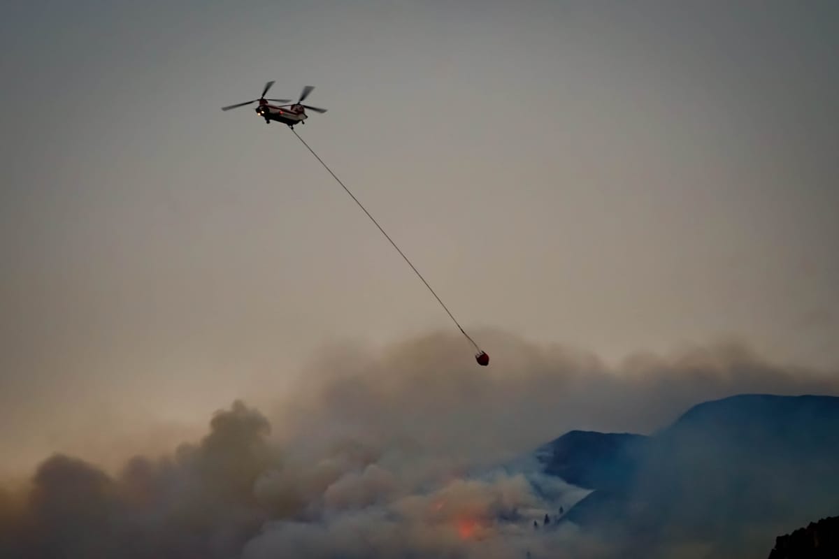
The INE release also overlays the hazard map onto the operational infrastructure file. The clearest finding: fire brigades show tighter proximity to the high-hazard zones than hospitals do, with the hospital network concentrated along the Atlantic littoral while the bombeiros voluntários network is distributed across the interior. The structural mismatch is the operational reason why evacuation distances and INEM transfer times — rather than first-response fire suppression — drive the human-cost variability in serious fire events in the interior.
The Map Behind the Numbers
The statistical release rests on the structural rural-fire-hazard map produced by ICNF under the national rural-fire-management framework (Programa Nacional de Gestão Integrada de Fogos Rurais, PNGIFR). The map classifies every cadastral parcel in the mainland on a five-tier hazard scale built from fuel load, topographic slope, aspect, historic fire history and proximity to ignition sources. The high and very-high tiers — the two INE consolidated into the 30.6% headline — are the categories that trigger the mandatory faixas de gestão de combustível clearing obligations on landowners, the building-code constraints under the Carta de Perigosidade de Incêndio Rural and the prioritisation of state preventive spending and aerial-asset basing through the operational DECIR deployment.
Why the Release Lands This Week
The publication lines up with the calendar end of the spring civil-protection planning cycle and the start of the operational fire season. The deployed asset side has already been moving: Defence Minister Nuno Melo confirmed the addition of two UH-60 Black Hawk helicopters to Portugal's 76-asset DECIR 2026 wildfire fleet in early May, and the parliamentary agenda has carried a government push to extend emergency disaster aid beyond wildfires to storms and earthquakes in the wake of the late-January Storm Kristin cluster. The INE release supplies the exposure-side denominator both files have been operating without an updated number.
How the Numbers Compare to Prior Cycles
The 30.6% mainland share in high/very-high tiers is broadly consistent with the structural read of recent years; the change in the 2026 release is the more granular regional and infrastructure overlay rather than a re-rating of the headline percentage. The 51,115-resident headcount is the more meaningful operational number for civil-protection planners, because it gives municipalities and the bombeiros a defensible population denominator for the plano municipal de defesa da floresta contra incêndios and the aldeias seguras registration files that drive resource allocation through the summer.
What This Means for Expats
- Foreign residents in the interior: if your property is in Centro or Norte, the structural hazard map is the document to read before the summer; the faixas de gestão de combustível obligation to clear a defined perimeter around buildings is enforceable and the municipal câmara will inspect.
- Buyers shopping in Trás-os-Montes, the Beiras or the Serra da Estrela perimeter: ask the seller's solicitador for the parcel's classification under the rural-fire-hazard map; the classification feeds into both the building-permit constraints and the insurance pricing for the policy bundle.
- Holiday-home owners: the Aldeias Seguras / Pessoas Seguras programme registration with the local câmara is the operational route to a self-protection plan; the registration is free and the municipal civil-protection office runs the briefing for residents.
- Households inside the hazard zones: the SMS-based Alerta SMS push from ANEPC, the 112 emergency line, the INEM number for medical emergencies and the 112.pt citizen portal are the four operational contacts; the population-tightness data in the INE release is the reason ANEPC has prioritised the SMS layer for these zones.
- Insurance: dwelling insurance for properties in high/very-high categories carries a fire-risk loading that the major Portuguese insurers — Fidelidade, Tranquilidade, Allianz, Generali — price off the same ICNF hazard map; a mid-summer renewal is the right time to confirm the loading is reflected.
Source: Instituto Nacional de Estatística — Destaque do INE, 'Áreas de perigosidade de incêndio rural', 22 May 2026; Programa Nacional de Gestão Integrada de Fogos Rurais (PNGIFR) and ICNF rural-fire-hazard cartography for the underlying classification framework.